'%3E%3Cmask id='b' fill='%23fff'%3E%3Cuse xlink:href='%23a'/%3E%3C/mask%3E%3Cuse fill='%23414141' xlink:href='%23a'/%3E%3Cg mask='url(%23b)' fill='%23414141'%3E%3Cpath d='M-160-170h300v300h-300z'/%3E%3C/g%3E%3C/g%3E%3C/g%3E%3C/svg%3E)

The Topography of War
The cartographers of TVA’s Maps and Surveys division were among the most admired mapmakers in the country. And that was before they played an important part in winning World War II.
Today U.S. Army mappers are hard at work plotting the complicated but tactically important topography of Afghanistan. More than seventy-five years ago, the Army was trying to figure out how to defeat a bigger, tougher enemy. And to map that enemy’s territories, it relied on TVA.
TVA has long been known to outdoors enthusiasts for its accurate topographic maps. When the agency set up a comprehensive mapping department in the 1930s, it was strictly for the purpose of studying the Tennessee Valley region and its physical configuration, which influenced erosion, flooding, reservoir construction and related matters.
At the end of the decade, TVA boasted of having charted a million acres, and its mapmaking reputation was spreading beyond the region. Those early cartographers could hardly have dreamed that one day they’d be poring over maps in other languages. Or that the department’s offices on East 11th Street in downtown Chattanooga, Tenn., would soon be involved in mapping three-quarters of a million square miles of territory on far continents. Or that most of what they charted would be behind enemy lines in the biggest war in history.
Protecting the Homeland
By 1939, the TVA region was one of the best-mapped regions in the nation. Most of the United States had never gotten the sort of careful geographic scrutiny TVA had focused on the Valley region. And that was the problem.
War was breaking out in Europe and Asia, and although this country wasn’t yet involved, some Army brass complained that the Axis powers might have better maps of America than America did. By the summer of 1941, the U.S. was still officially at peace with the world, but the Army was concerned about the possibility of an Axis invasion. And no federal agency was better prepared to map large territories than TVA.
TVA answered the Army’s call, taking on the job of mapping coastal areas and industrial facilities. Beginning with possible invasion sites in New York State, in South Carolina and on the Gulf Coast of Texas, the agency mapped some 24,000 square miles to assist in the prospective defense of America’s coastlines.
By early 1942, the United States was on the offensive in a world war. Too frequently, though, it was losing battles. Before the Allied forces could defeat the enemy, they had to map their positions so they could plan strategy and direct artillery fire. It was a huge challenge, and it soon became clear that the hastily assembled U.S. Army Map Service had a bigger job on its hands than it was prepared for.
Impressed with TVA’s work in the domestic-defense mapping project, the Army approached the agency in July 1943 for help in preparing surveys of enemy-held territories. The first assignment would be to map 30,000 square miles of Nazi-occupied France.
Joining the War Effort
Although it was suffering from wartime personnel attrition and was involved in several other major aspects of the war effort, TVA immediately pitched in. The jowly, bespectacled Ned H. Sayford, head of TVA’s Maps and Surveys division, led the conversion. Not all the transitions were graceful. Employees who were experts in land purchasing found themselves working on photo delineations; members of utility-relocation units were assigned to color in forested areas.
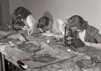
And then a lot of them got drafted. The war was borrowing most of the agency’s young men. From Maps and Surveys alone, the armed forces acquired 470 TVA mapping experts and technicians. TVA began hiring women to perform traditionally male roles ( see Home-Front Defenders), including mapping.
At first it had very narrow criteria for the women it hired. This was a discipline in which a thousandth of an inch could mean the difference between life and death for somebody in the field. The agency wanted college graduates, preferably ones with degrees in math or art. Soon there weren’t enough women left with those credentials, so college graduates in general would do. After a while TVA began hiring high school graduates, whom it trained to become expert mapmakers.
They worked at a considerable disadvantage. Obviously, carrying a sextant or transit around Nazi Germany was out of the question. The Army Map Service provided what it could, mainly old maps from its files and aerial photographs.
Sometimes the TVA cartographers had to work with maps from the Napoleonic era, comparing them with photographs taken from the air. They worked without the benefit of computers, employing the technique of photogrammetry, an approach that uses multiple exposures to suggest the depth of terrain. Photographs taken with stereoscopic cameras allowed the cartographers to chart Nazi-held land by its elevation above sea level. TVA’s multiplex equipment could translate the camera exposures.
Working with overhead projectors, the mapmakers loaded the photos onto a military grid marked off in increments of five-hundredths of an inch. One department was in charge of interpreting the aerial photos, another of editing them, and another of checking and double-checking the results. It was a huge process involving some 500 men and women, who worked nearly 1.5 million hours over the course of the war.
Mapping the Globe
After France, TVA mappers made charts of Austria, Holland, Poland, Yugoslavia—11 foreign countries in all, including Germany. They worked under pressure. One story says that General Eisenhower needed a map of France’s interior delivered to his headquarters in North Africa. The order came in to Chattanooga, and the maps were in Ike’s hands two days later. An estimated 70 million TVA-produced maps provided information for the Normandy invasion in June 1944.
As Germany shriveled, TVA turned its cartographic expertise on the Pacific, where maps were needed to plot locations for airstrips in places like jungle-covered New Guinea. Some were translated into other languages for use by America’s allies. Much of this massive operation remained relatively unknown, even in Chattanooga, until the Army approved the release of information about it in March 1945.
By the time the TVA staffers were done, Germany and Japan had been mapped more thoroughly than most of America—the parts of it outside the TVA region, anyway. TVA had already seen to that particular piece of real estate.
Soon after the war TVA was back to its old peacetime mapping pursuits, bolstered by its wartime experience and some impressive new equipment. In 1951 the agency was using a surplus P-38 fighter, equipped with sophisticated stereoscopic cameras instead of guns, to map the ever-changing Tennessee Valley region.