'%3E%3Cmask id='b' fill='%23fff'%3E%3Cuse xlink:href='%23a'/%3E%3C/mask%3E%3Cuse fill='%23414141' xlink:href='%23a'/%3E%3Cg mask='url(%23b)' fill='%23414141'%3E%3Cpath d='M-160-170h300v300h-300z'/%3E%3C/g%3E%3C/g%3E%3C/g%3E%3C/svg%3E)

Navigation on the Tennessee River
Though it may surprise some, the number one priority called for the TVA Act was to “improve the navigability” of the Tennessee River.
Navigation of the Tennessee River has always been a key to the economic development of the Tennessee Valley. Since Native Americans first loaded canoes into the Tennessee River, it had been used as an important mode of transportation for people and products. But it was riddled with hazards, including swift currents and rocky shoals (the most famous being the Muscle Shoals in Alabama). Periodic floods and droughts only made travel up and down the river worse.
Reliable Water Transportation
As the Valley’s population grew, so did its commerce. The need was strong for the government to create a reliable transportation system. The task fell to TVA, created by an act of congress in 1933. Along with flood control and hydropower generation, navigation was one of the main objectives for which the new agency was to manage the river—putting it to work for the people of the Valley.
By 1945, the navigation channel was essentially completed: a system of dams and locks set the stage for decades of thriving river traffic. Today, over 28,000 barges carry 45 to 50 million tons of goods up and down the Tennessee River annually.
Not only does it allow for the free flow of goods manufactured within, into and out of in the region, the navigation channel keeps costs down. Shipping by barge rather than by rail or truck reduces costs by an estimated $400 million each year— reductions that ease prices for consumers.
A Link to the World
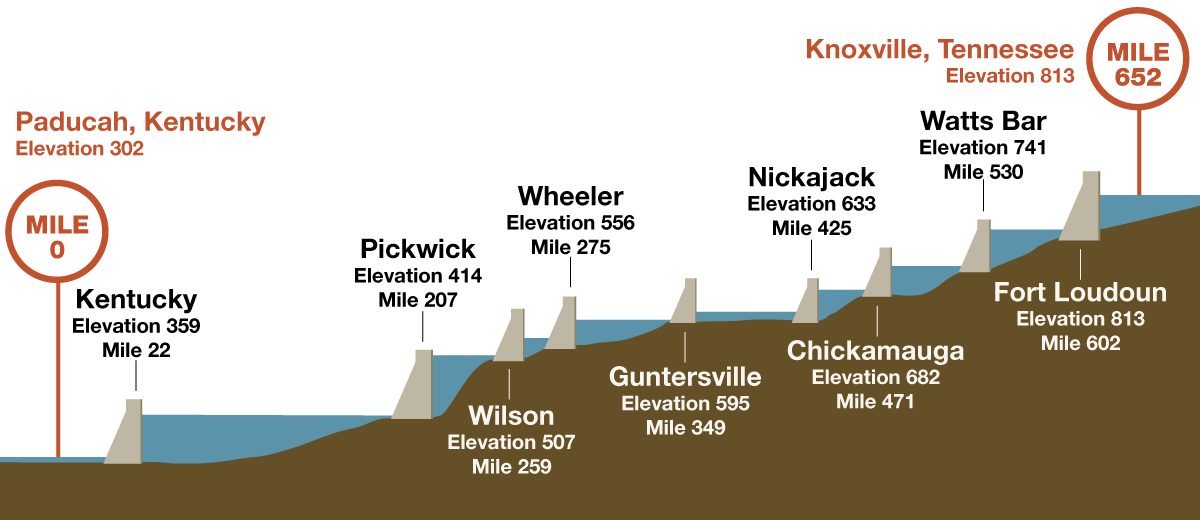
The Tennessee River’s main navigable channel is 652 miles long. It begins a mile above Knoxville, Tenn., and eventually joins with the Ohio River at Paducah, Ky. Commercial navigation also extends into three major tributaries: 61 miles up the Clinch River, 29 miles up the Little Tennessee River and 22 miles up the Hiwassee River. (An additional 374 miles of channel too shallow to handle commercial traffic is marked by TVA for recreational boating.)
The largest tributary of the Ohio River, the Tennessee River is part of the nation’s Inland Waterway System, along with the Mississippi, Missouri, Illinois and Arkansas rivers, as well as the Gulf Intercoastal Waterway and a host of smaller tributary rivers. Taken together, this system stretches 11,000 miles and reaches from Pennsylvania to Florida and from Texas to South Dakota, strategically linking geographic areas, major markets, suppliers of raw materials, processors and consumers.
Lake Info App

Want your lake info to go? Download the TVA Lake Info mobile app for iPhone and Android devices.